explore
Jungle Lowlands - Terrain
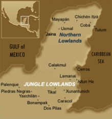
The Maya area can be divided into three geographical zones: the Southern Highlands, the Jungle Lowlands and the Northern Lowlands. These three regions are very distinct in terms of climate, terrain and history. The Southern Highland region is rugged and temperate, with many remote and cold high altitude areas. The central Jungle Lowlands are hot, tropical and heavily forested with annual rainfall above 200 cm. The Northern Lowlands are much drier and are characterized largely by scrub-brush dotted terrain. These very different landscapes encouraged regional differences in cultural expression. However, it is clear that despite these differences, the ancient Maya still held a great many traditions in common.
Image: Map of the Maya area.
In ancient times, as today, cultural boundaries defined regions, governed resources, and indicated the lineage and ancestral heritage of those who cultivated the land and waterways for survival and identity. The jungle lowlands of Mesoamerica are situated in the heartland of the ancient Maya, commonly called the Maya lowlands. Extensive river systems brought valuable trade items from great distances to lowland centres, for example obsidian from El Chayal and Kaminaljuyu, and also provided transportation for travelers and military operations.

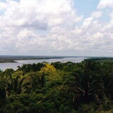
Image: View southward of the New River Lagoon from atop the 30m tall temple N10-43 (High Temple) at Lamanai, Belize. The city was situated along the shore of the lagoon, with direct access to the New River and from there to various other river systems. Lamanai was continuously occupied by the Maya for some 3,000 years, longer than any other Maya site yet found by archaeologists.